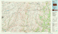
1985 Map of Sedan
USGS Topo · Published 1990About this map
The rolling prairies of the southern Kansas borderlands are defined by the winding course of the Caney River and its numerous tributaries. Centered on the town of Sedan, this region showcases a landscape shaped by both agriculture and industry, with an extensive Oil Field noted near the settlement of Salem. Significant transportation corridors include U.S. 160 and U.S. 166, which connect smaller communities like Cedar Vale, Dexter, and Peru.
Find a feature on this map
99 named features on this map. Tap any name to fly to it.
Don’t see what you’re looking for? This feature index may not catch every label — zoom into the map to look around manually.
Map Details
Editions of this 1985 Sedan Map
2 editions found
Other maps of this area

1885 · Eureka
USGS Topo · 1:125,000

1885 · Sedan
USGS Topo · 1:125,000

1886 · Fredonia
USGS Topo · 1:125,000

1886 · Independence
USGS Topo · 1:125,000

1888 · Eureka
USGS Topo · 1:125,000

1888 · Eldorado
USGS Topo · 1:125,000

1889 · Burden
USGS Topo · 1:125,000

1889 · Sedan
USGS Topo · 1:125,000

1889 · Wichita
USGS Topo · 1:125,000

1890 · Wellington
USGS Topo · 1:125,000