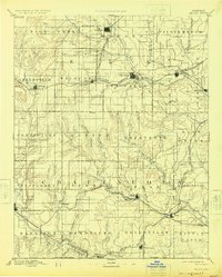
1889 Map of Sedan
USGS Topo · Published 1925About this map
Sedan serves as a primary hub in this late 19th-century survey of southeast Kansas, where the landscape is defined by the winding course of the Elk River and a dense network of early western railroads. The arrival of the Denver Memphis and Atlantic Railroad and the Atchison Topeka and Santa Fe Railroad transformed these prairies, connecting small agricultural centers like Moline, Grenola, and Elk Falls to larger markets.
Find a feature on this map
68 named features on this map. Tap any name to fly to it.
Don’t see what you’re looking for? This feature index may not catch every label — zoom into the map to look around manually.
Map Details
Editions of this 1889 Sedan Map
4 editions found
Other maps of this area

1885 · Eureka
USGS Topo · 1:125,000

1885 · Sedan
USGS Topo · 1:125,000

1886 · Fredonia
USGS Topo · 1:125,000

1886 · Independence
USGS Topo · 1:125,000

1888 · Eureka
USGS Topo · 1:125,000

1888 · Eldorado
USGS Topo · 1:125,000

1889 · Burden
USGS Topo · 1:125,000

1889 · Sedan
USGS Topo · 1:125,000

1894 · Fredonia
USGS Topo · 1:125,000

1894 · Independence
USGS Topo · 1:125,000