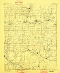
1889 Map of Sedan
USGS Topo · Published 1901About this map
Sedan and its surrounding townships anchor this late 19th-century survey of southeastern Kansas, a landscape defined by the convergence of growing rail networks and the winding Elk River. The map captures the region just as the expansion of the Atchison Topeka and Santa Fe Railroad and the Denver Memphis and Atlantic Railroad transformed local economies, linking prairie settlements like Moline and Elk Falls to larger markets. In the south, the Kansas Oklahoma Boundary Line marks the edge of the state near the cattle shipping point of Elgin. Smaller, dispersed communities such as Boston, Wauneta, and Cloverdale appear alongside numerous creek systems, including Caney Creek and Salt Creek, illustrating the early agrarian and trade-based settlement pattern before the intensification of later industrial shifts.
Find a feature on this map
70 named features on this map. Tap any name to fly to it.
Don’t see what you’re looking for? This feature index may not catch every label — zoom into the map to look around manually.
Map Details
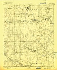
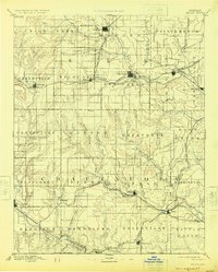
Editions of this 1889 Sedan Map
4 editions found
Other maps of this area

1885 · Eureka
USGS Topo · 1:125,000

1885 · Sedan
USGS Topo · 1:125,000

1886 · Fredonia
USGS Topo · 1:125,000

1886 · Independence
USGS Topo · 1:125,000

1888 · Eureka
USGS Topo · 1:125,000

1888 · Eldorado
USGS Topo · 1:125,000

1889 · Burden
USGS Topo · 1:125,000

1889 · Sedan
USGS Topo · 1:125,000

1894 · Fredonia
USGS Topo · 1:125,000

1894 · Independence
USGS Topo · 1:125,000