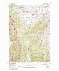
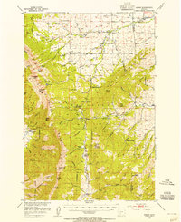
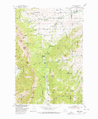
1951 Map of Sedan
USGS Topo · Published 1965About this map
Sedan and its neighboring ranchlands occupy the eastern slopes of the Bridger Range in this mid-century survey of the Gallatin National Forest. The landscape is defined by the high crest of the range, including prominent summits like Sacagawea Peak and Hardscrabble Peak, where Fairy Lake sits below the peaks. The settlement pattern follows the drainage of Brackett Creek and the various forks of Flathead Creek, with the Sedan School serving as a central community landmark.
Find a feature on this map
61 named features on this map. Tap any name to fly to it.
Don’t see what you’re looking for? This feature index may not catch every label — zoom into the map to look around manually.
Map Details
Editions of this 1951 Sedan Map
3 editions found
Other maps of this area

1886 · Fort Logan
USGS Topo · 1:250,000

1886 · Little Belt Mts.
USGS Topo · 1:250,000

1888 · Three Forks
USGS Topo · 1:250,000

1891 · Livingston
USGS Topo · 1:250,000

1893 · Livingston
USGS Topo · 1:250,000

1894 · Three Forks
USGS Topo · 1:250,000

1894 · Little Belt Mts.
USGS Topo · 1:250,000

1895 · Three Forks
USGS Topo · 1:250,000

1897 · Little Belt Mts.
USGS Topo · 1:250,000

1898 · Little Belt Mts.
USGS Topo · 1:250,000