
1965 Map of Sedan
USGS Topo · Published 1966About this map
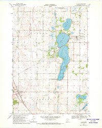
Sedan and the surrounding prairie wetlands are defined by the diagonal transit of the Soo Line railroad, which cuts across the townships of Bangor and Raymond in the mid-1960s. The landscape is a mosaic of agriculture and water, centered on the recreational and community hub at Grove Lake, where a Picnic Area and the Grove Lake Church anchor the local settlement. Further south, the map captures the northern edge of Brooten, marked by the Trinity Cemetery and the corporate boundary line.
Find a feature on this map
22 named features on this map. Tap any name to fly to it.
Don’t see what you’re looking for? This feature index may not catch every label — zoom into the map to look around manually.
Map Details
Editions of this 1965 Sedan Map
This is the sole edition of this map. No revisions or reprints were ever made.
Other maps of this area

1953 · Saint Cloud
USGS Topo · 1:250,000

1957 · Saint Cloud
USGS Topo · 1:250,000

1958 · Saint Cloud
USGS Topo · 1:250,000

1965 · Westport
USGS Topo · 1:24,000

1965 · Padua
USGS Topo · 1:24,000

1965 · Raymond Lake
USGS Topo · 1:24,000

1967 · Belgrade
USGS Topo · 1:24,000

1967 · Lake Johanna
USGS Topo · 1:24,000

1968 · Terrace
USGS Topo · 1:24,000
1968 · Villard
USGS Topo · 1:24,000