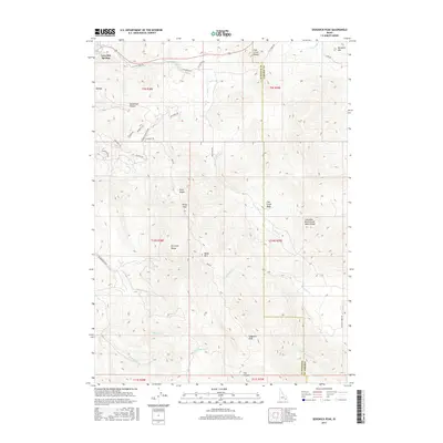
2017 Map of Sedgwick Peak
USGS Topo · Published 2017About this map
Lava Hot Springs occupies the northwestern corner of this study, positioned where the Portneuf River cuts through high mountain terrain. The landscape is dominated by the massive summits of the Portneuf Range and the Fish Creek Range, reaching its highest point at Sedgwick Peak in the southern reaches. A notable hydrologic feature is the Columbia River Great Basin Divide, which traverses the eastern slopes, separating the waters that flow toward the Pacific from those that remain in the interior basin. The map detail reflects a transition from the river valley into the high backcountry, where landmarks like Baldy Mtn and Buckskin Mtn overlook a complex network of seasonal drainages including Whiterock Cr and Dempsey Cr. This era shows significant recreational and local access via named routes such as the Wyoming Trl and Panamint Trl, which navigate the steep ascents between the peaks and the Fish Creek Basin.
Find a feature on this map
43 named features on this map. Tap any name to fly to it.
Don’t see what you’re looking for? This feature index may not catch every label — zoom into the map to look around manually.
Map Details
Editions of this 2017 Sedgwick Peak Map
This is the sole edition of this map. No revisions or reprints were ever made.
Other maps of this area

1915 · Preston
USGS Topo · 1:96,000

1918 · Preston
USGS Topo · 1:125,000

1948 · Bancroft
USGS Topo · 1:62,500

1949 · Bancroft
USGS Topo · 1:62,500

1954 · Pocatello
USGS Topo · 1:250,000

1955 · Preston
USGS Topo · 1:250,000

1958 · Pocatello
USGS Topo · 1:250,000

1958 · Preston
USGS Topo · 1:250,000

1962 · Preston
USGS Topo · 1:250,000
1968 · Downey East
USGS Topo · 1:24,000