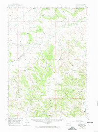
1957 Map of Seely
USGS Topo · Published 1974About this map
Little Missouri River drainage dominates this mid-century livestock-ranching landscape on the Montana Wyoming border. The territory is defined by a sparse network of family-held properties such as the Stoddard Ranch, Whitney Ranch, and Foster Ranch, many of which were serviced by a localized network of country schools. Educational outposts like Government Canyon Sch and Jay Sch highlight the dispersed settlement patterns typical of this era in the High Plains. To the south, the topography shifts near Strawberry Hill, where the Belle Fourche River cuts through the terrain. Notable local landmarks such as Lovers Leap and Bay Mtn rise above the complex system of draws and creeks, including Scoggin Draw and Engine Canyon, which provided vital drainage for the region's cattle and sheep operations during the 1950s.
Find a feature on this map
52 named features on this map. Tap any name to fly to it.
Don’t see what you’re looking for? This feature index may not catch every label — zoom into the map to look around manually.
Map Details
Editions of this 1957 Seely Map
2 editions found

Other maps of this area

1901 · Aladdin
USGS Topo · 1:125,000

1903 · Aladdin
USGS Topo · 1:125,000

1905 · Devils Tower
USGS Topo · 1:125,000

1954 · Strawberry Hill
USGS Topo · 1:24,000

1954 · Storm Hill
USGS Topo · 1:24,000

1954 · Ekalaka
USGS Topo · 1:250,000

1954 · Gillette
USGS Topo · 1:250,000

1955 · Devils Tower
USGS Topo · 1:62,500

1955 · Gillette
USGS Topo · 1:250,000

1956 · Ekalaka
USGS Topo · 1:250,000