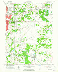
1963 Map of Seelyville
USGS Topo · Published 1965About this map
The eastern edge of Terre Haute meets a landscape defined by industry and education in this mid-century survey. Rose Polytechnic Institute and the expansive Highland Lawn Cemetery anchor the transition from the city into the surrounding coal and transit country of Seelyville and Riley. The terrain is marked by the legacy of early Indiana infrastructure, most notably the traces of the Wabash and Erie Canal (Abandoned) and the Central Canal (Abandoned) which once served as vital trade arteries. Aviation and national defense presence is significant, centered on Hulman Airport and the adjacent Indiana Air National Guard facility. Evidence of the region’s extractive history is found at the Mt Pleasant Mine, while smaller communities like Tabertown and Glen Ayr are joined by a dense network of rail lines including the Pennsylvania and Milwaukee Road.
Find a feature on this map
63 named features on this map. Tap any name to fly to it.
Don’t see what you’re looking for? This feature index may not catch every label — zoom into the map to look around manually.
Map Details
Editions of this 1963 Seelyville Map
4 editions found
Other maps of this area

1908 · Clay City
USGS Topo · 1:48,000

1910 · Clay City
USGS Topo · 1:62,500

1940 · Lewis
USGS Topo · 1:24,000

1940 · Pimento
USGS Topo · 1:24,000

1941 · Seelyville
USGS Topo · 1:24,000

1941 · Terre Haute
USGS Topo · 1:24,000

1948 · Terre Haute
USGS Topo · 1:24,000

1950 · Rosedale
USGS Topo · 1:24,000

1950 · Brazil West
USGS Topo · 1:24,000

1950 · New Goshen
USGS Topo · 1:24,000