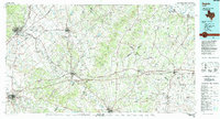
1985 Map of Seguin
USGS Topo · Published 1992About this map
The Salt Flat Oil Field and Darst Creek Oil Field dominate the landscape of the Blackland Prairie and Post Oak Savannah in the mid-1980s. This survey illustrates the dense energy infrastructure and agricultural patterns across the borderlands of Caldwell, Guadalupe, and Gonzales counties. Major transportation corridors, including Interstate 10 and the Southern Pacific Railroad, link established centers like Seguin, Lockhart, and Luling.
Find a feature on this map
112 named features on this map. Tap any name to fly to it.
Don’t see what you’re looking for? This feature index may not catch every label — zoom into the map to look around manually.
Map Details
Editions of this 1985 Seguin Map
2 editions found
Other maps of this area

1885 · Bastrop
USGS Topo · 1:125,000

1887 · Blanco
USGS Topo · 1:125,000

1893 · Bastrop
USGS Topo · 1:125,000

1894 · Blanco
USGS Topo · 1:125,000

1896 · Austin
USGS Topo · 1:125,000

1897 · Austin
USGS Topo · 1:125,000

1901 · Flatonia
USGS Topo · 1:125,000

1904 · Bastrop
USGS Topo · 1:125,000

1910 · Austin
USGS Topo · 1:125,000

1911 · San Marcos
USGS Topo · 1:125,000