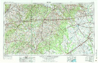
1953 Map of Seguin
USGS Topo · Published 1984About this map
The Guadalupe River and Colorado River systems carve through this expansive stretch of South Central Texas, defining a landscape of river-bottom agriculture and emerging oil production. This 1950s-era documentation, revised through the mid-1970s, captures the region's transition into a modern transportation hub as highways like U.S. Highway 90 and multiple rail lines, including the Southern Pacific RR, connect established centers like Seguin and Gonzales.
Find a feature on this map
211 named features on this map. Tap any name to fly to it.
Don’t see what you’re looking for? This feature index may not catch every label — zoom into the map to look around manually.
Map Details
Editions of this 1953 Seguin Map
4 editions found

Other maps of this area

1885 · Bastrop
USGS Topo · 1:125,000

1887 · Blanco
USGS Topo · 1:125,000

1893 · Bastrop
USGS Topo · 1:125,000

1894 · Blanco
USGS Topo · 1:125,000

1896 · Austin
USGS Topo · 1:125,000

1897 · Austin
USGS Topo · 1:125,000

1901 · Flatonia
USGS Topo · 1:125,000

1904 · Bastrop
USGS Topo · 1:125,000

1910 · Austin
USGS Topo · 1:125,000

1911 · San Marcos
USGS Topo · 1:125,000