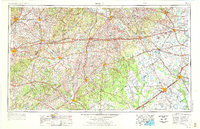
1953 Map of Seguin
USGS Topo · Published 1976About this map
The Guadalupe and Colorado river basins define the agricultural and industrial character of South Central Texas in this mid-century revision. Settlements such as Seguin, Lockhart, and Gonzales serve as central hubs for a landscape deeply etched by the corridors of the Southern Pacific RR and the Missouri-Kansas-Texas RR. To the east, the Brazos River marks the transition toward the coastal plains, passing near San Felipe and Stephen F. Austin State Park.
Find a feature on this map
135 named features on this map. Tap any name to fly to it.
Don’t see what you’re looking for? This feature index may not catch every label — zoom into the map to look around manually.
Map Details
Editions of this 1953 Seguin Map
4 editions found

Other maps of this area

1885 · Bastrop
USGS Topo · 1:125,000

1887 · Blanco
USGS Topo · 1:125,000

1893 · Bastrop
USGS Topo · 1:125,000

1894 · Blanco
USGS Topo · 1:125,000

1896 · Austin
USGS Topo · 1:125,000

1897 · Austin
USGS Topo · 1:125,000

1901 · Flatonia
USGS Topo · 1:125,000

1904 · Bastrop
USGS Topo · 1:125,000

1910 · Austin
USGS Topo · 1:125,000

1911 · San Marcos
USGS Topo · 1:125,000