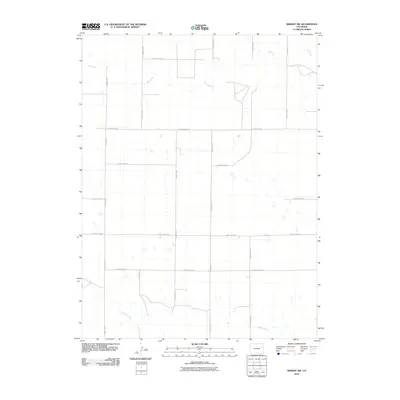
2010 Map of Seibert NW
USGS Topo · Published 2010About this map
Hell Creek and Buffalo Creek define the drainage of this High Plains landscape in northeastern Kit Carson County. The map reveals a strictly regulated section-line grid system, where travel is dictated by a network of rural routes such as County Road JJ and County Road GG. This 2010 survey illustrates the vast agricultural tracts of eastern Colorado, where the occasional depression and intermittent stream break the flat geometry of the land. Aside from the named waterways, the topography is characterized by a sparse, open character typical of the region's ranching and dryland farming areas. The layout of roads like County Rd-11 and County Rd-12 demonstrates how late-twentieth and early-twenty-first-century infrastructure continues to follow the original Public Land Survey System boundaries.
Find a feature on this map
14 named features on this map. Tap any name to fly to it.
Don’t see what you’re looking for? This feature index may not catch every label — zoom into the map to look around manually.
Map Details
Editions of this 2010 Seibert NW Map
This is the sole edition of this map. No revisions or reprints were ever made.
Other maps of this area

1954 · Limon
USGS Topo · 1:250,000

1957 · Limon
USGS Topo · 1:250,000

1958 · Limon
USGS Topo · 1:250,000

1977 · Cope SE
USGS Topo · 1:24,000

1977 · Anton SE
USGS Topo · 1:24,000

1977 · Cope SW
USGS Topo · 1:24,000

1979 · Seibert NE
USGS Topo · 1:24,000

1979 · Flagler
USGS Topo · 1:24,000
1979 · Flagler NE
USGS Topo · 1:24,000
1979 · Seibert NW
USGS Topo · 1:24,000