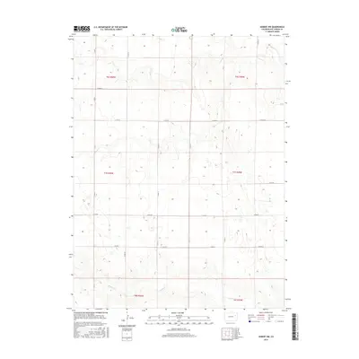
2016 Map of Seibert NW
USGS Topo · Published 2016About this map
Hell Cr and Buffalo Cr define the drainage of this High Plains landscape in Kit Carson County, carving shallow valleys through a predominantly agricultural grid. The terrain is organized by the Public Land Survey System, reflected in the township and range boundaries of t6s r50w, t7s r49w, and their neighbors. This 2016 survey illustrates the persistent importance of the section line road network, with numbered and lettered routes such as Co Rd 9 and Co Rd HH providing the primary infrastructure for the region's isolated farmsteads and ranchlands. The topography is subtle, showing numerous small depressions and intermittent water features typical of the semi-arid Colorado plains, where water management and land division are central to the local geography.
Find a feature on this map
19 named features on this map. Tap any name to fly to it.
Don’t see what you’re looking for? This feature index may not catch every label — zoom into the map to look around manually.
Map Details
Editions of this 2016 Seibert NW Map
This is the sole edition of this map. No revisions or reprints were ever made.
Other maps of this area

1954 · Limon
USGS Topo · 1:250,000

1957 · Limon
USGS Topo · 1:250,000

1958 · Limon
USGS Topo · 1:250,000

1977 · Cope SE
USGS Topo · 1:24,000

1977 · Anton SE
USGS Topo · 1:24,000

1977 · Cope SW
USGS Topo · 1:24,000

1979 · Seibert NE
USGS Topo · 1:24,000

1979 · Flagler
USGS Topo · 1:24,000
1979 · Flagler NE
USGS Topo · 1:24,000
1979 · Seibert NW
USGS Topo · 1:24,000