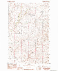
1984 Map of Seifort Reservoir
USGS Topo · Published 1984About this map
Seifort Reservoir serves as a central hydrological feature in this high plains landscape of Chouteau County, where the terrain is defined by a network of drainage systems and seasonal coulees. The map illustrates a primarily agricultural and ranching environment, marked by isolated infrastructure such as several clusters of Grain Bins located near the headwaters of the creeks. The land is dissected by Dog Creek in the north and the winding path of Eagle Creek to the west, reflecting the complex erosion patterns typical of this Montana region. Prominent landmarks like Haystack Butte provide vertical contrast to the surrounding drainage basins of Chip Creek and Sandstone Coulee. This provisional survey preserves the exact placement of local improvements and water management features used by area residents in the mid-1980s.
Find a feature on this map
7 named features on this map. Tap any name to fly to it.
Don’t see what you’re looking for? This feature index may not catch every label — zoom into the map to look around manually.
Map Details
Editions of this 1984 Seifort Reservoir Map
This is the sole edition of this map. No revisions or reprints were ever made.
Other maps of this area

1953 · Havre
USGS Topo · 1:250,000

1954 · Iliad
USGS Topo · 1:24,000

1954 · Dark Butte
USGS Topo · 1:24,000

1954 · Lewistown
USGS Topo · 1:250,000

1957 · Havre
USGS Topo · 1:250,000

1958 · Havre
USGS Topo · 1:250,000

1959 · Lewistown
USGS Topo · 1:250,000

1959 · Warrick
USGS Topo · 1:62,500

1959 · Centennial Mountain
USGS Topo · 1:62,500

1964 · Pigtail Coulee
USGS Topo · 1:24,000