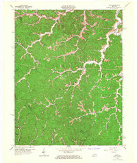
1965 Map of Seitz
USGS Topo · Published 1967About this map
The Licking River and its convoluted tributaries carve through the heart of the Cumberland Plateau in this 1960s survey of the Kentucky hill country. This region, where the borders of Magoffin, Morgan, Wolfe, and Breathitt counties converge, is characterized by a dense network of hollows and ridges that defined the settlement patterns of families in Seitz and Hendricks. The map captures a moment of transition for the local economy, where traditional life centered around rural institutions like Zion Ch and Puncheon Sch coexisted with the expanding industrial footprint of a Strip Mine and various smaller Mines found along the southern forks. The arrival of the Parkway Toll Road and Mountain Parkway in the north signifies a shift toward modern infrastructure, bypassing the older, winding ridge roads that formerly connected isolated schoolhouses like Wagers Sch and local burial grounds such as the Cutuno Burton Cem.
Find a feature on this map
79 named features on this map. Tap any name to fly to it.
Don’t see what you’re looking for? This feature index may not catch every label — zoom into the map to look around manually.
Map Details
Editions of this 1965 Seitz Map
2 editions found
Other maps of this area

1889 · Salyersville
USGS Topo · 1:125,000

1891 · Salyersville
USGS Topo · 1:125,000

1899 · Salyersville
USGS Topo · 1:125,000

1951 · Tiptop
USGS Topo · 1:24,000

1951 · Cannel City
USGS Topo · 1:24,000

1951 · Guage
USGS Topo · 1:24,000

1951 · White Oak
USGS Topo · 1:24,000
1951 · Salyersville North
USGS Topo · 1:24,000

1951 · Seitz
USGS Topo · 1:24,000

1951 · Quicksand
USGS Topo · 1:24,000