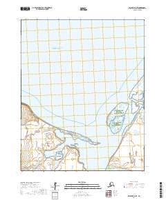
2017 Map of Selawik A-6 SW
USGS Topo · Published 2017About this map
Kiwalik sits at the junction of the open sea and tidal waters along the southern reaches of Kotzebue Sound. This coastal survey highlights the dynamic interface where Minnehaha Creek and Kirk Creek flow toward the protected waters of Kiwalik Lagoon. The landscape is defined by its transition from the marine environments of Spafarief Bay to the marshy lowlands protected under the Alaska Maritime National Wildlife Refuge. The settlement of Kiwalik is positioned strategically near the mouth of the lagoon, serving as a historical point of interest for those studying the maritime and transit history of the Northwest Arctic. The map's detail provides a clear view of the complex shoreline and drainage patterns typical of this subarctic coastal region.
Find a feature on this map
12 named features on this map. Tap any name to fly to it.
Don’t see what you’re looking for? This feature index may not catch every label — zoom into the map to look around manually.
Map Details
Editions of this 2017 Selawik A-6 SW Map
This is the sole edition of this map. No revisions or reprints were ever made.
Other maps of this area

1950 · Kotzebue A-1
USGS Topo · 1:63,360

1950 · Bendeleben
USGS Topo · 1:250,000

1950 · Bendeleben D-1
USGS Topo · 1:63,360

1951 · Candle
USGS Topo · 1:250,000

1951 · Selawik
USGS Topo · 1:250,000

1951 · Bendeleben
USGS Topo · 1:250,000

1951 · Kotzebue
USGS Topo · 1:250,000

1951 · Candle D-6
USGS Topo · 1:63,360

1951 · Selawik A-6
USGS Topo · 1:63,360

1955 · Candle
USGS Topo · 1:250,000