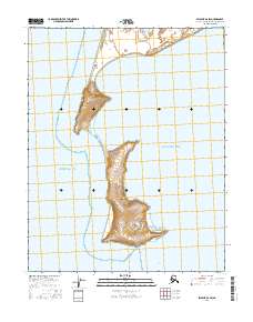
2016 Map of Selawik B-6 SW
USGS Topo · Published 2016About this map
Choris Peninsula extends into the coastal waters of Northwest Arctic, separating Kotzebue Sound from Eschscholtz Bay. This 2016 survey illustrates the narrow land bridge and elevated terrain of the peninsula, which terminates at the southern tip known as Point Garnet. The surrounding waters are critical to the region's maritime character, featuring the protected Chamisso Anchorage situated just south of the peninsula's point. This map provides a detailed topographic view of the peninsula's isolation and its geographic role as a barrier between these two significant bodies of water, highlighting a landscape defined by dramatic coastal transitions and remote shorelines.
Find a feature on this map
7 named features on this map. Tap any name to fly to it.
Don’t see what you’re looking for? This feature index may not catch every label — zoom into the map to look around manually.
Map Details
Editions of this 2016 Selawik B-6 SW Map
This is the sole edition of this map. No revisions or reprints were ever made.
Other maps of this area

1950 · Kotzebue A-1
USGS Topo · 1:63,360

1951 · Selawik
USGS Topo · 1:250,000

1951 · Kotzebue
USGS Topo · 1:250,000

1951 · Selawik B-6
USGS Topo · 1:63,360

1951 · Selawik A-6
USGS Topo · 1:63,360

1957 · Selawik
USGS Topo · 1:250,000

1958 · Kotzebue
USGS Topo · 1:250,000

1964 · Kotzebue
USGS Topo · 1:250,000
2014 · Selawik B-6 SE
USGS Topo · 1:25,000
2014 · Selawik A-6 NE
USGS Topo · 1:25,000