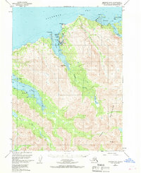
1951 Map of Seldovia B-5
USGS Topo · Published 1970About this map
The coastal village of Seldovia sits at the entrance to Seldovia Bay, serving as a central maritime and aviation hub for the lower Kenai Peninsula during the early 1950s. The landscape is defined by the steep transitions from the Kachemak Bay shoreline to the high elevations of the Kenai Mountains, where Mt Mills dominates the southern terrain. This 1951 aerial survey records the proximity of Indian Village to the main Seldovia settlement, illustrating the localized distribution of residents along the inlet. Further south, the community of Port Graham is established on the protected waters of its namesake port, near the complex tidal environment of the Selenie Mud Lagoon. Navigation and resource extraction are indicated by the Light at Seldovia Pt and a Mine located in the mountains above Jakolof Bay.
Find a feature on this map
33 named features on this map. Tap any name to fly to it.
Don’t see what you’re looking for? This feature index may not catch every label — zoom into the map to look around manually.
Map Details
Editions of this 1951 Seldovia B-5 Map
3 editions found
Other maps of this area

1946 · Seldovia C-5
USGS Topo · 1:63,360

1948 · Seldovia C-4
USGS Topo · 1:63,360

1949 · Seldovia C-4
USGS Topo · 1:62,500

1951 · Seldovia C-5
USGS Topo · 1:63,360

1951 · Seldovia
USGS Topo · 1:250,000

1951 · Seldovia B-5
USGS Topo · 1:63,360

1951 · Seldovia B-4
USGS Topo · 1:63,360

1951 · Seldovia A-6
USGS Topo · 1:63,360

1951 · Seldovia A-4
USGS Topo · 1:63,360

1951 · Seldovia B-6
USGS Topo · 1:63,360