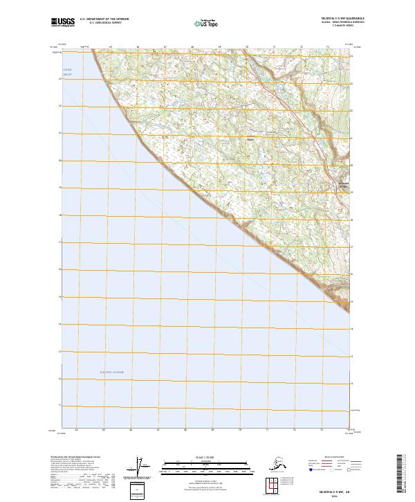
2024 Map of Seldovia C-5 NW
USGS Topo · Published 2024About this map
Cook Inlet and the Pacific Ocean dominate the western horizon of this Kenai Peninsula landscape, where the coastline transitions from the waters of the inlet into the elevated terrain of Diamond Ridge. The settlement of Anchor Point serves as a primary coastal hub, situated where the Anchor River approaches the shore. The land is defined by a series of drainage systems including Travers Creek, Troublesome Creek, and the deeply etched Mutnaia Gulch.
Find a feature on this map
28 named features on this map. Tap any name to fly to it.
Don’t see what you’re looking for? This feature index may not catch every label — zoom into the map to look around manually.
Map Details
Editions of this 2024 Seldovia C-5 NW Map
This is the sole edition of this map. No revisions or reprints were ever made.
Other maps of this area

1946 · Seldovia C-5
USGS Topo · 1:63,360

1946 · Seldovia D-5
USGS Topo · 1:63,360

1951 · Seldovia C-5
USGS Topo · 1:63,360

1951 · Seldovia D-5
USGS Topo · 1:63,360

1951 · Seldovia
USGS Topo · 1:250,000

1961 · Seldovia C-5
USGS Topo · 1:63,360
1961 · Seldovia D-5
USGS Topo · 1:63,360

1963 · Seldovia
USGS Topo · 1:250,000
1987 · Seldovia D-5 SE
USGS Topo · 1:25,000
1987 · Seldovia C-5 NW
USGS Topo · 1:25,000