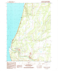
1987 Map of Seldovia D-5 SW
USGS Topo · Published 1987About this map
Anchor Point stands as a focal point along the eastern shore of Cook Inlet in this late-1980s landscape. The settlement's coastal identity is shaped by the confluence of the Anchor River and the inlet, where the Laida Spit and Laida Spit Slough form a distinct maritime boundary. To the north, Whiskey Gulch marks a notable indentation in the shoreline, while the interior is defined by a network of drainage systems including Stariski Creek and the North Fork Chakok River.
Find a feature on this map
25 named features on this map. Tap any name to fly to it.
Don’t see what you’re looking for? This feature index may not catch every label — zoom into the map to look around manually.
Map Details
Editions of this 1987 Seldovia D-5 SW Map
This is the sole edition of this map. No revisions or reprints were ever made.
Other maps of this area

1946 · Seldovia C-5
USGS Topo · 1:63,360

1946 · Seldovia D-5
USGS Topo · 1:63,360

1951 · Seldovia C-5
USGS Topo · 1:63,360

1951 · Seldovia D-5
USGS Topo · 1:63,360

1951 · Seldovia
USGS Topo · 1:250,000

1961 · Seldovia C-5
USGS Topo · 1:63,360
1961 · Seldovia D-5
USGS Topo · 1:63,360

1963 · Seldovia
USGS Topo · 1:250,000
1987 · Seldovia D-5 SE
USGS Topo · 1:25,000
1987 · Seldovia C-5 NW
USGS Topo · 1:25,000