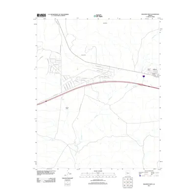
2011 Map of Seligman West
USGS Topo · Published 2011About this map
Seligman serves as the focal point of this 2011 survey, situated at a transition between the expansive Aubrey Valley and the rising terrain of Red Mesa. The settlement layout is defined by a dense grid of residential streets such as El Dorado Dr and Ventura Dr, clustered around the Seligman Post Office and the regional Seligman Airport. The landscape is etched by the intermittent drainage of Chino Wash, which winds past Chino Point toward the Railroad Embankment Reservoir. This desert infrastructure, including remote water sources like Shorty Tank and Quintanna Tank, highlights the importance of water management for both the community and the transportation corridors. Numerous local roads like Canyon Mouth Dam Rd and W Fort Rock Rd reach out from the town center into the surrounding Yavapai County rangeland.
Find a feature on this map
35 named features on this map. Tap any name to fly to it.
Don’t see what you’re looking for? This feature index may not catch every label — zoom into the map to look around manually.
Map Details
Editions of this 2011 Seligman West Map
This is the sole edition of this map. No revisions or reprints were ever made.
Other maps of this area

1886 · Diamond Creek
USGS Topo · 1:250,000

1886 · Chino
USGS Topo · 1:250,000

1891 · Chino
USGS Topo · 1:250,000

1892 · Diamond Creek
USGS Topo · 1:250,000

1947 · Turkey Canyon
USGS Topo · 1:62,500

1948 · Williams
USGS Topo · 1:250,000

1950 · Turkey Canyon
USGS Topo · 1:62,500

1954 · Williams
USGS Topo · 1:250,000

1956 · Williams
USGS Topo · 1:250,000

1960 · Williams
USGS Topo · 1:250,000