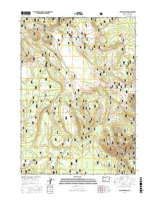
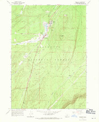
2017 Map of Sellers Marsh
USGS Topo · Published 2017About this map
Winema National Forest encompasses this high-elevation terrain in southern Oregon, where the landscape is defined by a series of high meadows and volcanic features. Central to the map is Sellers Marsh, a significant wetland area fed by Sellers Cr. The distribution of Johnson Meadow, Sprouls Meadow, and Round Meadow suggests a complex hydrological system typical of this region's volcanic plateaus. To the southeast, Parker Butte rises above the surrounding flats, while Pumice Flat reflects the area's geological history. A dense network of forest roads, such as Nat For Dev Rd 270 and Nat For Dev Rd 94, provides access to these timberlands and meadows. The presence of Dry Meadow Spring and Crooked Meadow further highlights the scattered water sources that have long drawn wildlife and seasonal users to these forest lands.
Find a feature on this map
29 named features on this map. Tap any name to fly to it.
Don’t see what you’re looking for? This feature index may not catch every label — zoom into the map to look around manually.
Map Details
Editions of this 2017 Sellers Marsh Map
This is the sole edition of this map. No revisions or reprints were ever made.
Other maps of this area

1935 · Chemult
USGS Topo · 1:96,000

1941 · Chemult
USGS Topo · 1:125,000

1955 · Crescent
USGS Topo · 1:250,000

1957 · Crescent
USGS Topo · 1:250,000

1958 · Crescent
USGS Topo · 1:250,000
1967 · Walker Mtn
USGS Topo · 1:24,000
1967 · Sellers Marsh
USGS Topo · 1:24,000
1967 · Crescent NE
USGS Topo · 1:24,000
1967 · Crescent
USGS Topo · 1:24,000

1968 · Location Butte
USGS Topo · 1:24,000