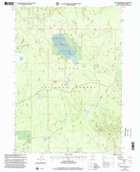
1999 Map of Sellers Marsh
USGS Topo · Published 2002About this map
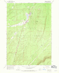
Sellers Marsh dominates this landscape within the Winema National Forest, representing a high-elevation wetland system defined by seasonal hydrology. The area is characterized by several distinct clearings and water sources, including Round Meadow, Crooked Meadow, and Dry Meadow, which indicate a history of grazing or resource management in this part of Klamath County. The topography is shaped by watercourses like Sellers Creek and Jack Creek, while Pumice Flat hints at the volcanic geology of the region. Evidence of historical land use appears in utilitarian markers such as a Corral, a Water Tank, and Meadow Spring, which supported livestock and forestry operations. The presence of the Standard Parallel South serves as a reminder of the foundational surveying work required to organize and manage these public forest lands at the close of the 20th century.
Find a feature on this map
14 named features on this map. Tap any name to fly to it.
Don’t see what you’re looking for? This feature index may not catch every label — zoom into the map to look around manually.
Map Details
Editions of this 1999 Sellers Marsh Map
This is the sole edition of this map. No revisions or reprints were ever made.
Other maps of this area

1935 · Chemult
USGS Topo · 1:96,000

1941 · Chemult
USGS Topo · 1:125,000

1955 · Crescent
USGS Topo · 1:250,000

1957 · Crescent
USGS Topo · 1:250,000

1958 · Crescent
USGS Topo · 1:250,000
1967 · Walker Mtn
USGS Topo · 1:24,000
1967 · Sellers Marsh
USGS Topo · 1:24,000
1967 · Crescent NE
USGS Topo · 1:24,000
1967 · Crescent
USGS Topo · 1:24,000

1968 · Location Butte
USGS Topo · 1:24,000