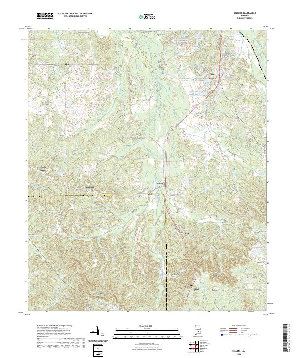
2024 Map of Sellers
USGS Topo · Published 2024About this map
Pintala Creek winds through the heart of this landscape, carving a valley that separates the rural hamlets of southern Montgomery County. The map documents a persistent pattern of small agricultural settlements and crossroads communities such as Fleta, Sellers, and Strata, where the road network follows the high ground between creek drainages. Significant for genealogical research, several distinct burial grounds are noted, including Fair Prospect Cem near Naftel and the Mount Olive Missionary Baptist Church Cem in the southwest. The boundary between Montgomery and Crenshaw Counties bisects the southern portion of the quadrangle, illustrating the transition from the upper coastal plain into the rolling hills of the Mt Carmel area. A high density of private impoundments like Bedsole Lake and Sellers Lake indicates the modern hydrologic character of these family-owned land tracts.
Find a feature on this map
83 named features on this map. Tap any name to fly to it.
Don’t see what you’re looking for? This feature index may not catch every label — zoom into the map to look around manually.
Map Details
Editions of this 2024 Sellers Map
This is the sole edition of this map. No revisions or reprints were ever made.
Other maps of this area

1953 · Montgomery
USGS Topo · 1:250,000

1953 · Andalusia
USGS Topo · 1:250,000

1956 · Montgomery
USGS Topo · 1:250,000

1957 · Montgomery
USGS Topo · 1:250,000

1957 · Andalusia
USGS Topo · 1:250,000

1957 · Letohatchee
USGS Topo · 1:62,500

1968 · Grady
USGS Topo · 1:24,000

1971 · Danielsville
USGS Topo · 1:24,000

1971 · Davis Crossroads
USGS Topo · 1:24,000
1971 · Ramer
USGS Topo · 1:24,000