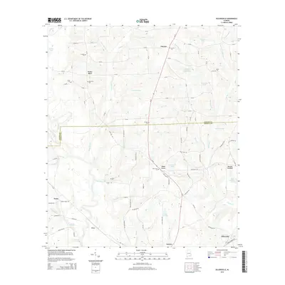
2014 Map of Sellersville
USGS Topo · Published 2014About this map
Pea River and its numerous tributaries, including Tiger Br and Beaverdam Br, dominate this rural landscape in southeastern Alabama. The region is marked by a network of small family and community burial grounds such as Macedonia Cem and Weeks Cem, which serve as vital landmarks for genealogical research. The settlement pattern is largely defined by rural junctions and local landmarks like Holley Store and the town of Sellersville in the southeast corner. The terrain is characterized by a high density of named ponds and small lakes, including James Wise Pond and Ted Averett Lake, reflecting the well-watered coastal plain environment. Notable water features like Faulk Millpond suggest a history of localized water-powered industry or land management integrated into the agricultural grid of Coffee and Geneva counties.
Find a feature on this map
104 named features on this map. Tap any name to fly to it.
Don’t see what you’re looking for? This feature index may not catch every label — zoom into the map to look around manually.
Map Details
Editions of this 2014 Sellersville Map
This is the sole edition of this map. No revisions or reprints were ever made.
Other maps of this area

1942 · Enterprise
USGS Topo · 1:125,000

1950 · Enterprise
USGS Topo · 1:62,500

1953 · Andalusia
USGS Topo · 1:250,000

1953 · Dothan
USGS Topo · 1:250,000

1954 · Dothan
USGS Topo · 1:250,000

1955 · Dothan
USGS Topo · 1:250,000

1957 · Andalusia
USGS Topo · 1:250,000

1957 · Geneva
USGS Topo · 1:62,500
1957 · Geneva West
USGS Topo · 1:24,000
1957 · Coffee Springs
USGS Topo · 1:24,000