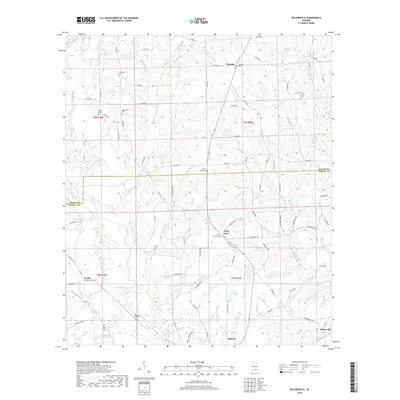
2018 Map of Sellersville
USGS Topo · Published 2018About this map
The Pea River and its numerous tributaries, including Faulk Mill Cr and Holley Mill Cr, define this rural stretch of the Alabama coastal plain across the Coffee and Geneva county line. Small settlements such as Fairview, Piney Grove, and Weeks are joined by the northern edges of Samson and Sellersville. The landscape is dotted with several family and community landmarks, such as Macedonia Cem and Mount Olive Cem, which offer significant value for genealogists studying the local area. The distribution of water features like Faulk Millpond and Sessions Pond suggests a history of localized water management and mill-based industry that shaped these communities. A dense network of rural roads, such as Tin Top Rd and Weeks Chapel Rd, provides a clear view of the dispersed agricultural settlement pattern during the 2010s.
Find a feature on this map
104 named features on this map. Tap any name to fly to it.
Don’t see what you’re looking for? This feature index may not catch every label — zoom into the map to look around manually.
Map Details
Editions of this 2018 Sellersville Map
This is the sole edition of this map. No revisions or reprints were ever made.
Other maps of this area

1942 · Enterprise
USGS Topo · 1:125,000

1950 · Enterprise
USGS Topo · 1:62,500

1953 · Andalusia
USGS Topo · 1:250,000

1953 · Dothan
USGS Topo · 1:250,000

1954 · Dothan
USGS Topo · 1:250,000

1955 · Dothan
USGS Topo · 1:250,000

1957 · Andalusia
USGS Topo · 1:250,000

1957 · Geneva
USGS Topo · 1:62,500
1957 · Geneva West
USGS Topo · 1:24,000
1957 · Coffee Springs
USGS Topo · 1:24,000