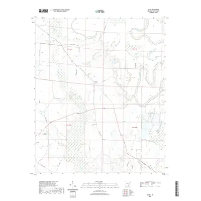
2020 Map of Selma
USGS Topo · Published 2020About this map
The settlement of Selma sits at a geographic crossroads in Drew County, where the terrestrial road network meets the complex hydrology of the Arkansas Delta. The eastern edge of the map is defined by the winding course of Bayou Bartholomew, which creates a series of oxbow features and wetlands known locally as brakes, including Milk Track Brake, Trotters Brake, and Horseshoe Brake. These features indicate a landscape shaped by historical river migrations and seasonal flooding, creating a distinctive pattern of low-lying wetlands interspersed with agricultural land.
Find a feature on this map
47 named features on this map. Tap any name to fly to it.
Don’t see what you’re looking for? This feature index may not catch every label — zoom into the map to look around manually.
Map Details
Editions of this 2020 Selma Map
This is the sole edition of this map. No revisions or reprints were ever made.
Other maps of this area

1935 · Cominto
USGS Topo · 1:62,500

1935 · Rotan
USGS Topo · 1:62,500

1935 · Red Fork
USGS Topo · 1:62,500

1936 · McGehee
USGS Topo · 1:62,500

1937 · McGehee
USGS Topo · 1:62,500

1953 · Greenwood
USGS Topo · 1:250,000

1955 · McGehee
USGS Topo · 1:62,500

1956 · Greenwood
USGS Topo · 1:250,000

1960 · Selma
USGS Topo · 1:24,000

1960 · Collins NW
USGS Topo · 1:24,000