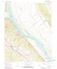
1964 Map of Selma
USGS Topo · Published 1982About this map
Mississippi River transport and rail connections dominate this riverfront landscape along the border of Missouri and Illinois. In the early 1960s, the river remains a massive geographic force, defined here by Calico Island and Harlow Island. Along the Missouri banks, the Burlington Northern railroad serves industrial and community nodes, connecting the riverfront at Selma (Sta) and Rush Tower. On the bluff overlooking the water, the St Joseph Ursuline Novitiate and Selma Sch mark the institutional footprint of the area. Across the state line in Illinois, the rail-oriented settlement at Maeys (Maeystown Sta) and the crossing at Chalfin Bridge sit in the low-lying bottoms protected by the Selma Ditch. The map reveals a transition between the elevated topography of Buck Knob and the broad floodplains that dictated the placement of local infrastructure and ferry landings like Kemper Landing.
Find a feature on this map
37 named features on this map. Tap any name to fly to it.
Don’t see what you’re looking for? This feature index may not catch every label — zoom into the map to look around manually.
Map Details
Editions of this 1964 Selma Map
3 editions found
Other maps of this area

1910 · Waterloo
USGS Topo · 1:62,500

1912 · Kimmswick
USGS Topo · 1:62,500

1913 · Waterloo
USGS Topo · 1:62,500

1915 · Renault
USGS Topo · 1:62,500

1915 · Crystal City
USGS Topo · 1:62,500

1916 · Kimmswick
USGS Topo · 1:62,500

1940 · Renault
USGS Topo · 1:62,500

1948 · Kimmswick
USGS Topo · 1:62,500

1949 · Saint Louis
USGS Topo · 1:250,000

1949 · Crystal City
USGS Topo · 1:62,500