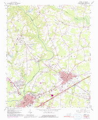
1964 Map of Selma
USGS Topo · Published 1992About this map
The Neuse River winds through this Johnston County landscape, carving a path between the growing settlements of Smithfield and Wilsons Mills during the mid-1960s. The region is defined by its transit history, showing the prominent intersection of the Southern and Seaboard Coast Line railroads at Selma. This rail junction served as a vital pulse point for the surrounding agricultural and industrial areas, including several gravel operations such as the Sand and Gravel Pits near the riverbanks.
Find a feature on this map
73 named features on this map. Tap any name to fly to it.
Don’t see what you’re looking for? This feature index may not catch every label — zoom into the map to look around manually.
Map Details
Editions of this 1964 Selma Map
3 editions found

Other maps of this area

1902 · Kenly
USGS Topo · 1:62,500

1903 · Kenly
USGS Topo · 1:62,500

1906 · Four Oaks
USGS Topo · 1:48,000

1908 · Four Oaks
USGS Topo · 1:62,500

1953 · Raleigh
USGS Topo · 1:250,000

1954 · Raleigh
USGS Topo · 1:250,000

1964 · Flowers
USGS Topo · 1:24,000

1964 · Selma
USGS Topo · 1:62,500

1964 · Clayton
USGS Topo · 1:24,000

1964 · Powhatan
USGS Topo · 1:24,000