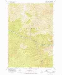
1966 Map of Selway Falls
USGS Topo · Published 1978About this map
The Selway River dominates this mid-1960s survey of a wild reach within the Nez Perce National Forest. The landscape is defined by the steep descent of the river as it passes Selway Falls Guard Station and a notable Fish Ladder designed for fish passage. This area, largely untouched by major roads, relies on an extensive network of Pack Trails that connect remote landmarks like Timothy Flats and Glover Ridge.
Find a feature on this map
31 named features on this map. Tap any name to fly to it.
Don’t see what you’re looking for? This feature index may not catch every label — zoom into the map to look around manually.
Map Details
Editions of this 1966 Selway Falls Map
3 editions found
Other maps of this area

1911 · Lolo
USGS Topo · 1:250,000

1913 · Lolo
USGS Topo · 1:250,000

1956 · Elk City
USGS Topo · 1:250,000

1956 · Hamilton
USGS Topo · 1:250,000

1959 · Hamilton
USGS Topo · 1:250,000

1960 · Elk City
USGS Topo · 1:250,000

1960 · Hamilton
USGS Topo · 1:250,000

1964 · Hamilton
USGS Topo · 1:250,000

1966 · Selway Falls
USGS Topo · 1:24,000

1966 · Lick Point
USGS Topo · 1:24,000