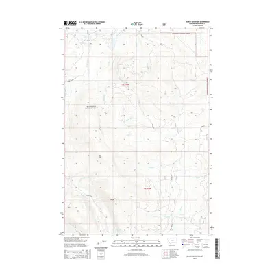
2014 Map of Selway Mountain
USGS Topo · Published 2014About this map
Beaverhead National Forest contains the high-elevation terrain of this southwest Montana landscape, where the Big Hole River and its numerous tributaries dominate the hydrology. The map reveals a complex network of forest access routes like Skinner Meadows Rd and Bloody Dick Rd that navigate the high peaks and basins. Significant summits such as Selway Mtn and Black Mtn stand as primary landmarks above the alpine valleys. Water is the defining characteristic of the area, evidenced by the presence of Van Houten Lake, Reservoir Lake, and the smaller Mud Lake. The drainage patterns are intricate, with Saginaw Cr and Englebaugh Cr cutting through the slopes of the Selway Mtn range. This survey provides an essential look at the modern forest infrastructure and natural topography of the region, emphasizing the remote nature of the Continental Divide backcountry.
Find a feature on this map
33 named features on this map. Tap any name to fly to it.
Don’t see what you’re looking for? This feature index may not catch every label — zoom into the map to look around manually.
Map Details
Editions of this 2014 Selway Mountain Map
This is the sole edition of this map. No revisions or reprints were ever made.
Other maps of this area

1955 · Dillon
USGS Topo · 1:250,000

1956 · Goldstone Mtn
USGS Topo · 1:62,500

1957 · Dillon
USGS Topo · 1:250,000

1958 · Dillon
USGS Topo · 1:250,000

1962 · Dillon
USGS Topo · 1:250,000

1965 · Dillon
USGS Topo · 1:250,000

1966 · Miner Lake
USGS Topo · 1:24,000
1978 · Jackson
USGS Topo · 1:24,000

1978 · Butch Hill
USGS Topo · 1:24,000
1978 · Coyote Creek
USGS Topo · 1:24,000