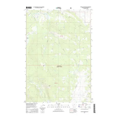
2017 Map of Selway Mountain
USGS Topo · Published 2017About this map
Beaverhead National Forest defines this high-altitude landscape of southwestern Montana, where the upper reaches of the Big Hole River and Bloody Dick Creek emerge from the slopes of the Bitterroot Range. This recent survey illustrates a terrain of significant hydrologic importance, featuring numerous alpine water bodies such as Van Houten Lake, Reservoir Lake, and Mud Lake. The presence of the Fish Ranch Airport in the western valley highlights the specialized transportation needs of this remote backcountry, which is otherwise accessed via forest routes like Saginaw Road and Bloody Dick Road. Distinct topographic landmarks, including Selway Mountain, Black Mountain, and the open expanses of Dunkwadell Flats, provide clear orientation for researchers tracking land use and resource management within the national forest boundaries.
Find a feature on this map
32 named features on this map. Tap any name to fly to it.
Don’t see what you’re looking for? This feature index may not catch every label — zoom into the map to look around manually.
Map Details
Editions of this 2017 Selway Mountain Map
This is the sole edition of this map. No revisions or reprints were ever made.
Other maps of this area

1955 · Dillon
USGS Topo · 1:250,000

1956 · Goldstone Mtn
USGS Topo · 1:62,500

1957 · Dillon
USGS Topo · 1:250,000

1958 · Dillon
USGS Topo · 1:250,000

1962 · Dillon
USGS Topo · 1:250,000

1965 · Dillon
USGS Topo · 1:250,000

1966 · Miner Lake
USGS Topo · 1:24,000
1978 · Jackson
USGS Topo · 1:24,000

1978 · Butch Hill
USGS Topo · 1:24,000
1978 · Coyote Creek
USGS Topo · 1:24,000