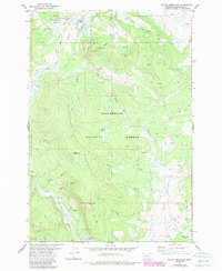
1978 Map of Selway Mountain
USGS Topo · Published 1989About this map
Jackson Cow Camp and the small settlement of Jahnke anchor this high-country landscape within the Beaverhead National Forest. This 1970s survey, updated in the late 1980s, reveals a terrain defined by the headwaters of the Big Hole River and the mining legacy at the Saginaw Mine. The map traces a complex network of resource extraction and seasonal grazing infrastructure, including the Davis Ditch and a remote Landing Strip near Skinner Meadows.
Find a feature on this map
36 named features on this map. Tap any name to fly to it.
Don’t see what you’re looking for? This feature index may not catch every label — zoom into the map to look around manually.
Map Details
Editions of this 1978 Selway Mountain Map
This is the sole edition of this map. No revisions or reprints were ever made.
Other maps of this area

1955 · Dillon
USGS Topo · 1:250,000

1956 · Goldstone Mtn
USGS Topo · 1:62,500

1957 · Dillon
USGS Topo · 1:250,000

1958 · Dillon
USGS Topo · 1:250,000

1962 · Dillon
USGS Topo · 1:250,000

1965 · Dillon
USGS Topo · 1:250,000

1966 · Miner Lake
USGS Topo · 1:24,000
1978 · Jackson
USGS Topo · 1:24,000

1978 · Butch Hill
USGS Topo · 1:24,000
1978 · Coyote Creek
USGS Topo · 1:24,000