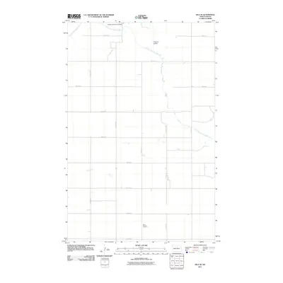
2011 Map of Selz NE
USGS Topo · Published 2011About this map
The North Fork Sheyenne River meanders across this rural section of Benson County, shaping a landscape defined by seasonal water flow and drainage features like Trappers Coulee. In this agricultural region, the Buffalo Lake Diversion Dam indicates the management of prairie waterways for local utility. The grid-like layout of section lines and gravel roads, such as 40th St NE and 37th Ave NE, organizes the vast prairie into a network of farmsteads. For those looking into local lineage, the Saint Boniface Cemetery sits in the southern portion of the quadrangle, serving as a significant landmark for family history and the cultural footprint of the early settlers who organized these townships.
Find a feature on this map
18 named features on this map. Tap any name to fly to it.
Don’t see what you’re looking for? This feature index may not catch every label — zoom into the map to look around manually.
Map Details
Editions of this 2011 Selz NE Map
This is the sole edition of this map. No revisions or reprints were ever made.
Other maps of this area

1941 · Selz
USGS Topo · 1:62,500

1943 · Maddock
USGS Topo · 1:62,500

1945 · Maddock
USGS Topo · 1:62,500

1950 · Wellsburg
USGS Topo · 1:24,000
1951 · Harvey
USGS Topo · 1:24,000

1951 · Selz NE
USGS Topo · 1:24,000

1951 · Selz NW
USGS Topo · 1:24,000
1951 · Heimdal
USGS Topo · 1:24,000

1951 · Hesper
USGS Topo · 1:24,000

1952 · New Rockford
USGS Topo · 1:250,000