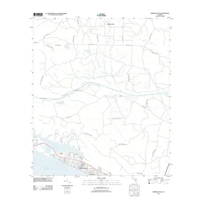
2012 Map of Seminole Hills
USGS Topo · Published 2012About this map
Hollywood Beach and Sunnyside anchor the southern coastal edge of this Florida panhandle survey, where the residential development along the Gulf of Mexico meets the expansive conservation lands to the north. This geography is defined by the transition from the beach-side grid of streets like Marlin Ave and Sunset Ave to the large-scale management of the Point Washington WMA and Pine Log State Frst. The hydrology of the area is particularly distinct, featuring the coastal dune lake system of Powell Lake and its connection to the sea at Philips Inlet. Inland, the landscape rises into the Seminole Hills, drained by watercourses such as Otter Creek and W Bay Creek, while the named settlement of Laird sits further north. The map also captures the varied terrain of the Poley Islands and the drainage at Broomstraw Branch, providing a clear view of the area's natural state before further development.
Find a feature on this map
49 named features on this map. Tap any name to fly to it.
Don’t see what you’re looking for? This feature index may not catch every label — zoom into the map to look around manually.
Map Details
Editions of this 2012 Seminole Hills Map
This is the sole edition of this map. No revisions or reprints were ever made.
Other maps of this area

1936 · Point Washington
USGS Topo · 1:48,000

1939 · Point Washington
USGS Topo · 1:62,500

1943 · Laguna Beach
USGS Topo · 1:31,680

1943 · Panama City Beach
USGS Topo · 1:31,680

1943 · Seminole Hills
USGS Topo · 1:24,000

1943 · West Bay
USGS Topo · 1:24,000

1944 · Seminole Hills
USGS Topo · 1:31,680

1944 · West Bay
USGS Topo · 1:31,680

1944 · Bruce
USGS Topo · 1:24,000

1945 · Red Head
USGS Topo · 1:31,680