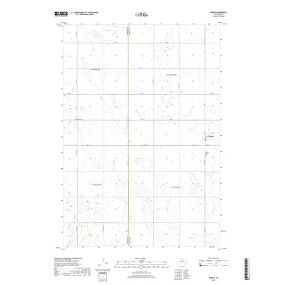
2017 Map of Seneca
USGS Topo · Published 2017About this map
Seneca stands as a primary focal point in this portion of the northern plains, situated along the Potter Co Faulk Co line. The landscape is defined by the high-plains topography of South Dakota, where the headwaters and drainages such as S Fork Snake Cr carve through the agricultural grid. This survey preserves the layout of local infrastructure just south of the town center, including the Saint Boniface Cem. The map illustrates a shift in regional transit, showing the path of Old Us Hwy 212 as it bypasses the older sections of the township. This modern survey reflects the enduring section-line road network that has organized the Dakotas for generations, connecting isolated homesteads and field access points through named routes like 327 Ave and 157th St.
Find a feature on this map
27 named features on this map. Tap any name to fly to it.
Don’t see what you’re looking for? This feature index may not catch every label — zoom into the map to look around manually.
Map Details
Editions of this 2017 Seneca Map
This is the sole edition of this map. No revisions or reprints were ever made.
Other maps of this area

1950 · Onaka
USGS Topo · 1:24,000

1951 · Rezac Lake NW
USGS Topo · 1:24,000

1952 · Onaka
USGS Topo · 1:24,000

1952 · Onaka SW
USGS Topo · 1:24,000

1953 · Huron
USGS Topo · 1:250,000

1954 · Aberdeen
USGS Topo · 1:250,000

1954 · Huron
USGS Topo · 1:250,000

1956 · Aberdeen
USGS Topo · 1:250,000

1965 · Onaka
USGS Topo · 1:24,000
1978 · Bald Hills
USGS Topo · 1:24,000