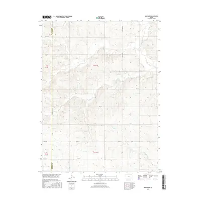
2015 Map of Seneca NW
USGS Topo · Published 2015About this map
The Marshall County and Nemaha County border defines the western edge of this rural landscape, where the high plains are deeply dissected by a network of seasonal and perennial waterways. Wildcat Cr and its northern tributary, N Fork Wildcat Cr, drain the southern reaches, while Pole Cr and Turkey Cr flow through the northern sections. This topography dictated the placement of the section-line road network, visible in the alignment of Baileyville Rd and Arrowhead Rd. The map illustrates a contemporary agricultural environment structured by the Public Land Survey System, with township and range lines such as t1s r11e carving the terrain into a predictable grid. Local hydrology is further represented by Clear Cr and Negro Cr, which weave between the surveyed boundaries and rural routes like Bison Rd and Granite Rd.
Find a feature on this map
23 named features on this map. Tap any name to fly to it.
Don’t see what you’re looking for? This feature index may not catch every label — zoom into the map to look around manually.
Map Details
Editions of this 2015 Seneca NW Map
This is the sole edition of this map. No revisions or reprints were ever made.
Other maps of this area

1889 · Seneca
USGS Topo · 1:125,000

1894 · Seneca
USGS Topo · 1:125,000

1955 · Manhattan
USGS Topo · 1:250,000

1955 · Lincoln
USGS Topo · 1:250,000

1956 · Manhattan
USGS Topo · 1:250,000

1957 · Manhattan
USGS Topo · 1:250,000

1957 · Lincoln
USGS Topo · 1:250,000

1958 · Lincoln
USGS Topo · 1:250,000

1965 · Pawnee City
USGS Topo · 1:24,000
1965 · Du Bois
USGS Topo · 1:24,000