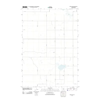
2012 Map of Seneca NW
USGS Topo · Published 2012About this map
Alkali Lake sits in the northeastern corner of this Potter County landscape, a prominent hydrological feature in a region defined by its rigid section-line road network. The map reveals the quiet, rural character of the Great Plains, where the grid of 324th Ave, 327th Ave, and numbered streets like 148th St organize the vast agricultural space. Two burial grounds, Advent Cem and Spring Cem, are the primary markers of local heritage and genealogy on this sheet. The presence of these small cemeteries at rural intersections, separated by several miles of open country, illustrates the dispersed settlement pattern typical of the South Dakota prairie in the early twenty-first century.
Find a feature on this map
18 named features on this map. Tap any name to fly to it.
Don’t see what you’re looking for? This feature index may not catch every label — zoom into the map to look around manually.
Map Details
Editions of this 2012 Seneca NW Map
This is the sole edition of this map. No revisions or reprints were ever made.
Other maps of this area

1954 · Aberdeen
USGS Topo · 1:250,000

1956 · Aberdeen
USGS Topo · 1:250,000

1974 · Hoven
USGS Topo · 1:24,000

1974 · Hoven Muni. Airport
USGS Topo · 1:24,000

1974 · Bowdle SE
USGS Topo · 1:24,000
1978 · Tolstoy
USGS Topo · 1:24,000

1978 · Seneca NW
USGS Topo · 1:24,000
1978 · Seneca SW
USGS Topo · 1:24,000
1978 · Seneca
USGS Topo · 1:24,000

1978 · Bowdle SW
USGS Topo · 1:24,000