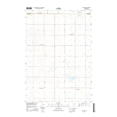
2015 Map of Seneca NW
USGS Topo · Published 2015About this map
The northern reaches of Potter County meet the borders of Walworth and Edmunds counties in this 2015 study of the South Dakota plains. The landscape is defined by its glacial depressions and ephemeral hydrology, most notably the Alkali Lake area in the north and the Fresh Pond (historical) basin to the south. These features, along with Alkali Flat (historical), suggest a terrain where water was once more permanent than the present-day prairie suggests. Settlement is sparse, characterized by the rigid mile-grid of the Public Land Survey System, with gravel roads like 151st ST and 323rd Ave providing the primary access through the townships. For local historians and genealogists, the placement of the Advent Cem and Spring Cem provides critical anchors for understanding the dispersal of early rural communities across these northern Great Plains townships.
Find a feature on this map
27 named features on this map. Tap any name to fly to it.
Don’t see what you’re looking for? This feature index may not catch every label — zoom into the map to look around manually.
Map Details
Editions of this 2015 Seneca NW Map
This is the sole edition of this map. No revisions or reprints were ever made.
Other maps of this area

1954 · Aberdeen
USGS Topo · 1:250,000

1956 · Aberdeen
USGS Topo · 1:250,000

1974 · Hoven
USGS Topo · 1:24,000

1974 · Hoven Muni. Airport
USGS Topo · 1:24,000

1974 · Bowdle SE
USGS Topo · 1:24,000
1978 · Tolstoy
USGS Topo · 1:24,000

1978 · Seneca NW
USGS Topo · 1:24,000
1978 · Seneca SW
USGS Topo · 1:24,000
1978 · Seneca
USGS Topo · 1:24,000

1978 · Bowdle SW
USGS Topo · 1:24,000