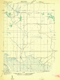
1931 Map of Seney NW
USGS Topo · Published 1931About this map
State Highway No 77 bisects this northern Michigan landscape, where the headwaters of the Fox River and Tahquamenon systems converge during the early 1930s. The map reveals a transition between the northern high ground of the Alger and Schoolcraft county line and the extensive wetlands to the south. This region is characterized by numerous small lakes and ponds, such as Dutch Fred Lake, Snyder Lake, and the cluster of Tahquamenon Lakes in the northeast. The presence of Lavender Corner at the intersection of the highway and the county boundary provides a specific point of reference for local historians. Of particular interest to researchers of the region's logging era is Camp No 7 Creek, which hints at the temporary lumber camps that once peppered this wooded terrain. Numerous waterways, including Haymeadow Creek and Coal Creek, illustrate the complex drainage patterns of this Upper Peninsula wilderness.
Find a feature on this map
19 named features on this map. Tap any name to fly to it.
Don’t see what you’re looking for? This feature index may not catch every label — zoom into the map to look around manually.
Map Details
Editions of this 1931 Seney NW Map
2 editions found
Other maps of this area

1931 · Seney SW
USGS Topo · 1:31,680

1931 · Seney NW
USGS Topo · 1:31,680

1931 · Driggs Lake NE
USGS Topo · 1:31,680

1931 · Seney SE
USGS Topo · 1:31,680

1931 · Driggs Lake SE
USGS Topo · 1:31,680

1954 · Sault Sainte Marie
USGS Topo · 1:250,000

1956 · Sault Sainte Marie
USGS Topo · 1:250,000

1957 · Sault Sainte Marie
USGS Topo · 1:250,000

1958 · Sault Sainte Marie
USGS Topo · 1:250,000

1958 · Marquette
USGS Topo · 1:250,000