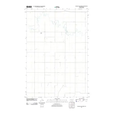
2011 Map of Senger Lake North
USGS Topo · Published 2011About this map
Sacred Heart Cemetery stands as a quiet cultural landmark in this rural landscape of Emmons County, North Dakota. The area is defined by the winding course of Beaver Creek, which meanders through the northern section of the territory, creating a distinct riparian pattern against the rigid grid of the surrounding agricultural landscape. This survey documents the network of section-line roads, such as 83rd St SE and 14th Ave SE, which facilitate the movement of goods and people across the plains. The lack of concentrated urban development highlights the agricultural character of the region, where the placement of cemeteries and water sources serves as the primary orientation for local history and genealogical research.
Find a feature on this map
16 named features on this map. Tap any name to fly to it.
Don’t see what you’re looking for? This feature index may not catch every label — zoom into the map to look around manually.
Map Details
Editions of this 2011 Senger Lake North Map
This is the sole edition of this map. No revisions or reprints were ever made.
Other maps of this area

1953 · Jamestown
USGS Topo · 1:250,000

1954 · Bismarck
USGS Topo · 1:250,000

1956 · Jamestown
USGS Topo · 1:250,000

1958 · Bismarck
USGS Topo · 1:250,000

1971 · Strasburg
USGS Topo · 1:24,000

1979 · Senger Lake North
USGS Topo · 1:24,000
1979 · Westfield
USGS Topo · 1:24,000
1979 · Senger Lake South
USGS Topo · 1:24,000

1979 · Schell Buttes SW
USGS Topo · 1:24,000
1980 · Linton
USGS Topo · 1:24,000