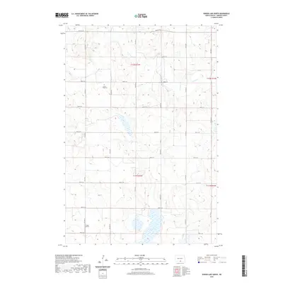
2020 Map of Senger Lake North
USGS Topo · Published 2020About this map
Sacred Heart Cem stands as a focal point for family history in this corner of Emmons County, situated among the section lines and prairie coulees of south-central North Dakota. The landscape is defined by the seasonal drainage of Beaver Cr and the presence of Senger Lake in the southern portion of the township. This 2020 survey reveals a highly structured rural grid, where the movement of people and livestock is dictated by numbered section-line roads such as 81st St SE and 13th Ave SE. Near the southwestern corner, Voller Airport provides a small aviation hub for the local agricultural community. The map provides an exacting look at the modern Public Land Survey System layout, tracing the boundaries between t132n r75w and surrounding townships, useful for researchers documenting precise land ownership and ancestral farmsteads.
Find a feature on this map
23 named features on this map. Tap any name to fly to it.
Don’t see what you’re looking for? This feature index may not catch every label — zoom into the map to look around manually.
Map Details
Editions of this 2020 Senger Lake North Map
This is the sole edition of this map. No revisions or reprints were ever made.
Other maps of this area

1953 · Jamestown
USGS Topo · 1:250,000

1954 · Bismarck
USGS Topo · 1:250,000

1956 · Jamestown
USGS Topo · 1:250,000

1958 · Bismarck
USGS Topo · 1:250,000

1971 · Strasburg
USGS Topo · 1:24,000

1979 · Senger Lake North
USGS Topo · 1:24,000
1979 · Westfield
USGS Topo · 1:24,000
1979 · Senger Lake South
USGS Topo · 1:24,000

1979 · Schell Buttes SW
USGS Topo · 1:24,000
1980 · Linton
USGS Topo · 1:24,000