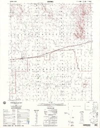
1995 Map of Sentinel
USGS Topo · Published 1995About this map
Sentinel sits at the heart of an arid landscape defined by the logistics of the desert Southwest in the early 1990s. The settlement and nearby Piedra are linked by the Southern Pacific railroad, which parallels the highway across the Sentinel Plain and Tartron Flat. This area serves as a transition between transport corridors and the expansive Barry M Goldwater Air Force Range, which occupies the southern portion of the map. Evidence of military and aviation activity is prominent, including a Landing Strip, a Radio Tower, and several control towers.
Find a feature on this map
20 named features on this map. Tap any name to fly to it.
Don’t see what you’re looking for? This feature index may not catch every label — zoom into the map to look around manually.
Map Details
Editions of this 1995 Sentinel Map
This is the sole edition of this map. No revisions or reprints were ever made.
Other maps of this area

1927 · Aguila Mountains
USGS Topo · 1:48,000

1927 · Hyder
USGS Topo · 1:62,500

1929 · Aztec
USGS Topo · 1:62,500

1930 · Aguila Mountains
USGS Topo · 1:62,500

1930 · Hyder
USGS Topo · 1:62,500

1942 · Vicksburg
USGS Topo · 1:250,000

1949 · Sentinel
USGS Topo · 1:62,500

1950 · Sentinel
USGS Topo · 1:62,500

1950 · Theba
USGS Topo · 1:62,500

1950 · Aztec
USGS Topo · 1:62,500