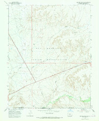
1966 Map of Sentinel Peak SW
USGS Topo · Published 1970About this map
The Ute Mountain Indian Reservation covers the majority of this mid-1960s survey, revealing a landscape defined by deep drainage systems and early industrial activity. The Mancos River flows across the southern portion of the sheet, while major ephemeral channels like Cowboy Wash and Aztec Wash carve through the arid terrain. For those interested in archaeology and historical land use, the presence of Indian Ruins near the river indicates the long-term habitation of these canyons. The map also documents a modern layer of development, showing a prominent Pipeline cutting diagonally across the reservation alongside scattered energy infrastructure such as Well No A-4 and several designated drill holes. This intersection of ancient sites and 20th-century resource extraction highlights the changing utility of this region in Southwest Colorado.
Find a feature on this map
13 named features on this map. Tap any name to fly to it.
Don’t see what you’re looking for? This feature index may not catch every label — zoom into the map to look around manually.
Map Details
Editions of this 1966 Sentinel Peak SW Map
3 editions found
Other maps of this area

1886 · Abajo
USGS Topo · 1:250,000

1889 · Chaco
USGS Topo · 1:250,000

1892 · Abajo
USGS Topo · 1:250,000

1892 · Chaco
USGS Topo · 1:250,000

1892 · Canyon De Chelly
USGS Topo · 1:250,000

1893 · Abajo
USGS Topo · 1:250,000

1934 · Rattlesnake
USGS Topo · 1:62,500

1937 · Rattlesnake
USGS Topo · 1:62,500

1953 · Pastora Peak NE
USGS Topo · 1:24,000

1953 · Pastora Peak
USGS Topo · 1:62,500