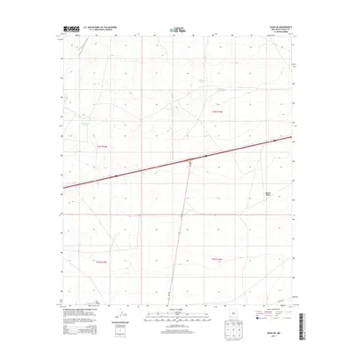
2013 Map of Separ NE
USGS Topo · Published 2013About this map
The Continental Divide winds through this high-desert landscape in Grant County, marking the hydrological spine of the region. This 2013 survey documents a sparsely populated area defined by essential water infrastructure and remote outposts. Named landmarks like Guess Place and The Saltys suggest a history of localized ranching or individual land claims in a terrain where water sources are vital. Artificial water catchments, including Sappington Tank and Government Tank, are scattered across the quadrangle, supporting livestock and wildlife where natural drainage like Burro Cienaga may be seasonal. The transport network is anchored by the north-south corridor of NM-146 and the utilitarian Pipeline Rd, which cut through the public land survey system grid of Township 24 South and 25 South.
Find a feature on this map
12 named features on this map. Tap any name to fly to it.
Don’t see what you’re looking for? This feature index may not catch every label — zoom into the map to look around manually.
Map Details
Editions of this 2013 Separ NE Map
This is the sole edition of this map. No revisions or reprints were ever made.
Other maps of this area

1954 · Silver City
USGS Topo · 1:250,000

1958 · Silver City
USGS Topo · 1:250,000

1962 · Silver City
USGS Topo · 1:250,000

1962 · Ninetysix Ranch
USGS Topo · 1:24,000

1963 · Gage SW
USGS Topo · 1:24,000

1963 · Soldiers Farewell Hill
USGS Topo · 1:24,000

1963 · Gage NW
USGS Topo · 1:24,000
1963 · Grandmother Mountain West
USGS Topo · 1:24,000
1964 · The Saltys
USGS Topo · 1:24,000
1964 · Separ NE
USGS Topo · 1:24,000