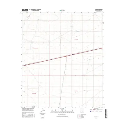
2017 Map of Separ NE
USGS Topo · Published 2017About this map
Burro Cienaga cuts through the high desert of southwestern New Mexico, marking a landscape defined by water management and arid-land ranching. In this 2017 study, the drainage patterns of the high basins are articulated by several catchment features, including Government Tank, Sappington Tank, and the notably named Continental Divide Tank. These water sources were vital for sustaining the livestock industry that shaped the early settlement patterns of Grant County.
Find a feature on this map
11 named features on this map. Tap any name to fly to it.
Don’t see what you’re looking for? This feature index may not catch every label — zoom into the map to look around manually.
Map Details
Editions of this 2017 Separ NE Map
This is the sole edition of this map. No revisions or reprints were ever made.
Other maps of this area

1954 · Silver City
USGS Topo · 1:250,000

1958 · Silver City
USGS Topo · 1:250,000

1962 · Silver City
USGS Topo · 1:250,000

1962 · Ninetysix Ranch
USGS Topo · 1:24,000

1963 · Gage SW
USGS Topo · 1:24,000

1963 · Soldiers Farewell Hill
USGS Topo · 1:24,000

1963 · Gage NW
USGS Topo · 1:24,000
1963 · Grandmother Mountain West
USGS Topo · 1:24,000
1964 · The Saltys
USGS Topo · 1:24,000
1964 · Separ NE
USGS Topo · 1:24,000