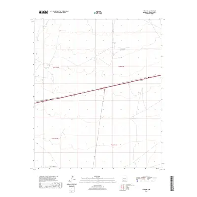
2020 Map of Separ NE
USGS Topo · Published 2020About this map
Burro Cienaga defines the northwestern corner of this high-desert landscape in Grant County, where the infrastructure of water management and modern transportation intersects. The terrain is characterized by a network of drainage channels and man-made reservoirs, including Government Tank, Sappington Tank, and the appropriately named Continental Divide Tank. These features point to the critical role of livestock ranching and water rights in this arid region of New Mexico. In the southern reaches of the quadrangle, The Saltys suggests a low-lying alkali flat or ephemeral drainage. Cutting through the center of the survey is a major interstate corridor flanked by Frontage Rd, illustrating the modern transit artery that bisects these expansive township and range sections.
Find a feature on this map
10 named features on this map. Tap any name to fly to it.
Don’t see what you’re looking for? This feature index may not catch every label — zoom into the map to look around manually.
Map Details
Editions of this 2020 Separ NE Map
This is the sole edition of this map. No revisions or reprints were ever made.
Other maps of this area

1954 · Silver City
USGS Topo · 1:250,000

1958 · Silver City
USGS Topo · 1:250,000

1962 · Silver City
USGS Topo · 1:250,000

1962 · Ninetysix Ranch
USGS Topo · 1:24,000

1963 · Gage SW
USGS Topo · 1:24,000

1963 · Soldiers Farewell Hill
USGS Topo · 1:24,000

1963 · Gage NW
USGS Topo · 1:24,000
1963 · Grandmother Mountain West
USGS Topo · 1:24,000
1964 · The Saltys
USGS Topo · 1:24,000
1964 · Separ NE
USGS Topo · 1:24,000