1943 Map of Sequatchie
USGS Topo · Published 1946About this map
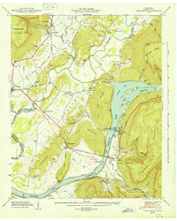
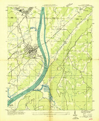
The Sequatchie Valley serves as a corridor for industry and transportation in the early 1940s, anchored by the Hales Bar Power Plant along the Tennessee River. This era is defined by the Tennessee Valley Authority's landscape engineering, shown through the extent of the Hales Bar Lake Reservoir and the Guntersville Reservoir. Settlement patterns follow the Nashville Chattanooga and St Louis RR, which connects Sequatchie and Jasper to the broader regional economy. Evidence of earlier river-based life remains visible at Rankin Ferry (Abandoned), which once linked the valley floor to the base of Anderson Mountain. Local history is deeply preserved in rural institutions like Wesley Chapel, Haveron Chapel, and the Marion County Home. The rugged geography of Walden Ridge and Raccoon Mountain hems in the agricultural valley, where family names are fixed to the land via landmarks like Pryors Island and Inman Point.
Find a feature on this map
91 named features on this map. Tap any name to fly to it.
Don’t see what you’re looking for? This feature index may not catch every label — zoom into the map to look around manually.
Map Details
Editions of this 1943 Sequatchie Map
This is the sole edition of this map. No revisions or reprints were ever made.
Other maps of this area

1886 · Ringgold
USGS Topo · 1:125,000

1886 · Stevenson
USGS Topo · 1:125,000

1888 · Chattanooga
USGS Topo · 1:125,000

1892 · Ringgold
USGS Topo · 1:125,000

1892 · Stevenson
USGS Topo · 1:125,000

1893 · Chattanooga
USGS Topo · 1:125,000

1895 · Stevenson
USGS Topo · 1:125,000

1895 · Sewanee
USGS Topo · 1:125,000

1936 · Shellmound
USGS Topo · 1:24,000
1936 · Bridgeport
USGS Topo · 1:24,000