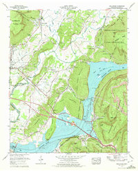
1970 Map of Sequatchie
USGS Topo · Published 1972About this map
Nickajack Lake and Guntersville Lake dominate this landscape where the Tennessee River cuts through the ridges of the Cumberland Plateau. The map documents a significant hydraulic transition, noting the site of the Hales Bar Dam (demolished) and the development of the Marion Memorial Bridge crossing. Along the river banks, small communities like Haletown and Ladds sit near the foot of Aetna Mountain, while the northern reaches include the Prentice Cooper State Forest and the Walden Ridge wildlife area.
Find a feature on this map
87 named features on this map. Tap any name to fly to it.
Don’t see what you’re looking for? This feature index may not catch every label — zoom into the map to look around manually.
Map Details
Editions of this 1970 Sequatchie Map
2 editions found
Other maps of this area

1886 · Ringgold
USGS Topo · 1:125,000

1886 · Stevenson
USGS Topo · 1:125,000

1888 · Chattanooga
USGS Topo · 1:125,000

1892 · Ringgold
USGS Topo · 1:125,000

1892 · Stevenson
USGS Topo · 1:125,000

1893 · Chattanooga
USGS Topo · 1:125,000

1895 · Stevenson
USGS Topo · 1:125,000

1895 · Sewanee
USGS Topo · 1:125,000

1936 · Shellmound
USGS Topo · 1:24,000

1936 · Bridgeport
USGS Topo · 1:24,000