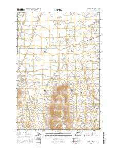
2014 Map of Service Buttes
USGS Topo · Published 2014About this map
Oregon Trail Rd cuts across this high desert landscape, marking a modern path along the historic corridor of westward migration. The terrain is defined by the prominent Service Buttes in the south, where steep contour lines rise above the surrounding plateau. Water management is a central theme in this arid region, evidenced by the intricate network of Hunt Ditch and Courtney Ditch in the north, which likely support the agricultural productivity of the Echo Meadows area. These irrigation features contrast with natural water sources like Service Springs and Vey Spring. The geometric precision of the Public Land Survey System, including townships t3n r28e and t2n r28e, provides a framework for the ranch roads like Eagle Ranch Rd and Gordon Creek Rd that service the isolated canyons and gulches.
Find a feature on this map
22 named features on this map. Tap any name to fly to it.
Don’t see what you’re looking for? This feature index may not catch every label — zoom into the map to look around manually.
Map Details
Editions of this 2014 Service Buttes Map
This is the sole edition of this map. No revisions or reprints were ever made.
Other maps of this area

1908 · Umatilla
USGS Topo · 1:125,000

1953 · Pendleton
USGS Topo · 1:250,000

1956 · Pendleton
USGS Topo · 1:250,000

1962 · Stanfield
USGS Topo · 1:24,000

1962 · Ordnance
USGS Topo · 1:24,000

1962 · Hermiston
USGS Topo · 1:24,000

1968 · Service Buttes NW
USGS Topo · 1:24,000
1968 · Echo
USGS Topo · 1:24,000

1968 · Vey Ranch
USGS Topo · 1:24,000

1968 · Butter Creek Junction
USGS Topo · 1:24,000